 ANVIL
ANVILCatch the storm
before it catches you.
Anvil Weather is a professional-grade severe weather workstation: live NEXRAD Level 2 radar in seconds, volumetric 3D storms with dual-radar wind trajectories, street-level immersion, a 30+ year archive of history's biggest events, HRRR future mode, deep interrogation tools and 40+ overlays — in one fast, beautiful app.
Free forever for live base radar + NWS warnings. Create a free account and you're in.
Built for severe weather days
Everything a spotter, analyst, broadcaster or weather enthusiast needs to understand the storm — from anywhere.
Live Level 2 radar, fast
Real-time chunked NEXRAD feed with seconds of latency, smooth loop playback, velocity dealiasing, max-value trails, and GPU rendering that stays fluid while you pan and zoom.
30+ years of radar history PRO
Replay any storm since 1991 — or jump straight into the Notable Events catalog: Joplin, Moore, El Reno, Mayfield and more, with historical SPC reports, NWS damage surveys, tornado tracks and damage paths on the map.
Storms in true 3D PRO
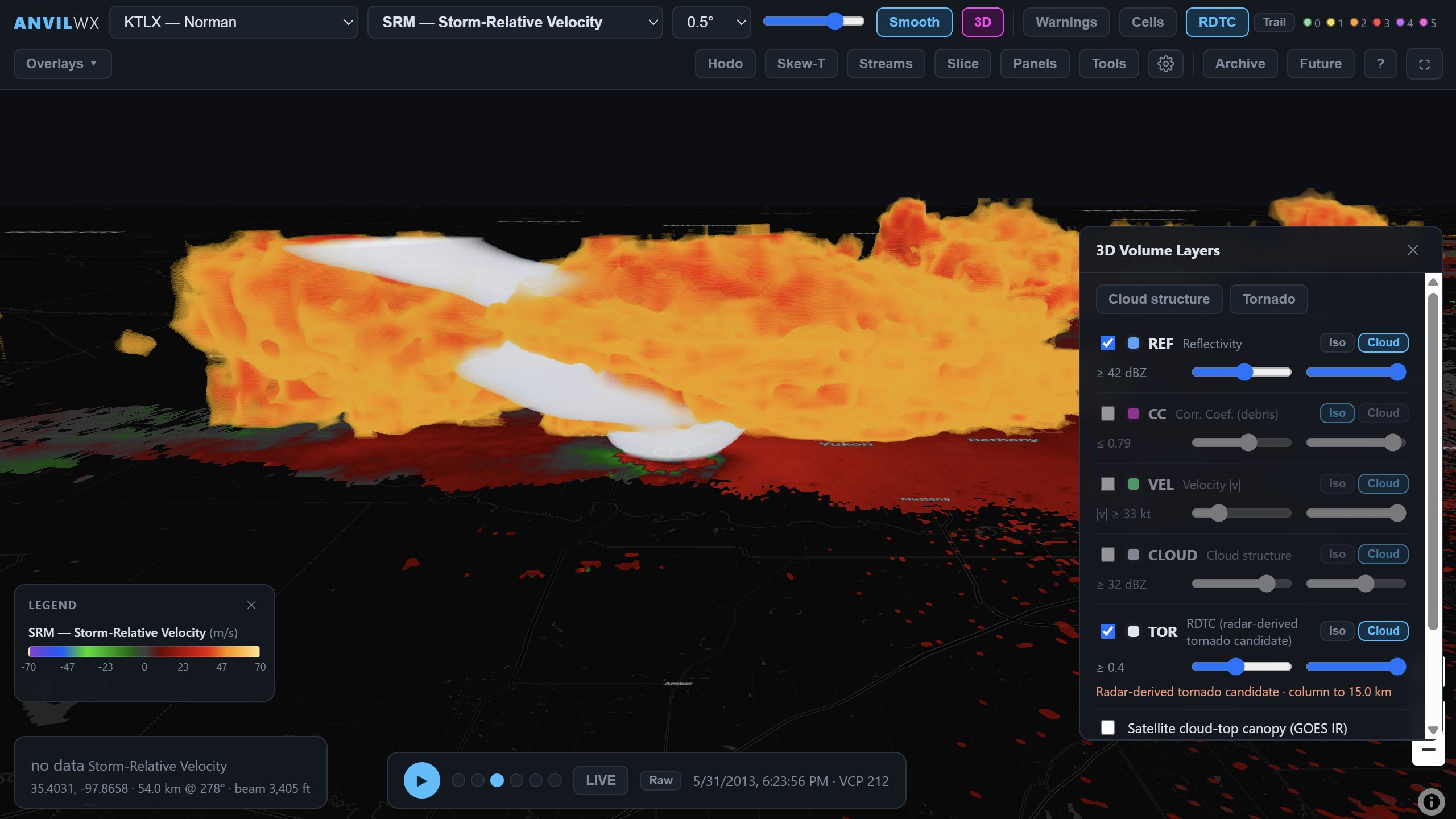
Raymarched volumetric reflectivity, rotation and debris iso-surfaces on the real map, height rings, a GOES cloud-top canopy draped over the storm — and one-click KMZ export to Google Earth.
Dual-radar wind retrieval PRO
Pair two WSR-88Ds for true dual-Doppler wind fields: 3D wind velocity trajectories, streamlines, updraft/downdraft and RFD structure — research-grade analysis with CSV/GeoJSON export.
Street-level immersion PRO
Drop into a ground-level spotter camera under the storm: cinematic sky, rain, lightning and ambient audio, driven by the real radar volume above you.
See the future with HRRR PRO
Future mode extends your timeline ~24 hours ahead with HRRR simulated reflectivity, updraft helicity, gusts, snow and freezing rain — plus a 0–60 minute radar nowcast.
Interrogate everything PRO
VAD hodographs with time-height view, Skew-T soundings from HRRR/GFS/ECMWF/RAOB, and an Inspect tool: click any point to read every active overlay at once — or pull the full NWS forecast for that spot.
Alerts where you care
Monitor your location, your pins, the map view or hand-drawn custom areas. Per-hazard filters, escalation tones for PDS and Tornado Emergency, desktop notifications and lightning-proximity alerts.
An overlay for everything PRO
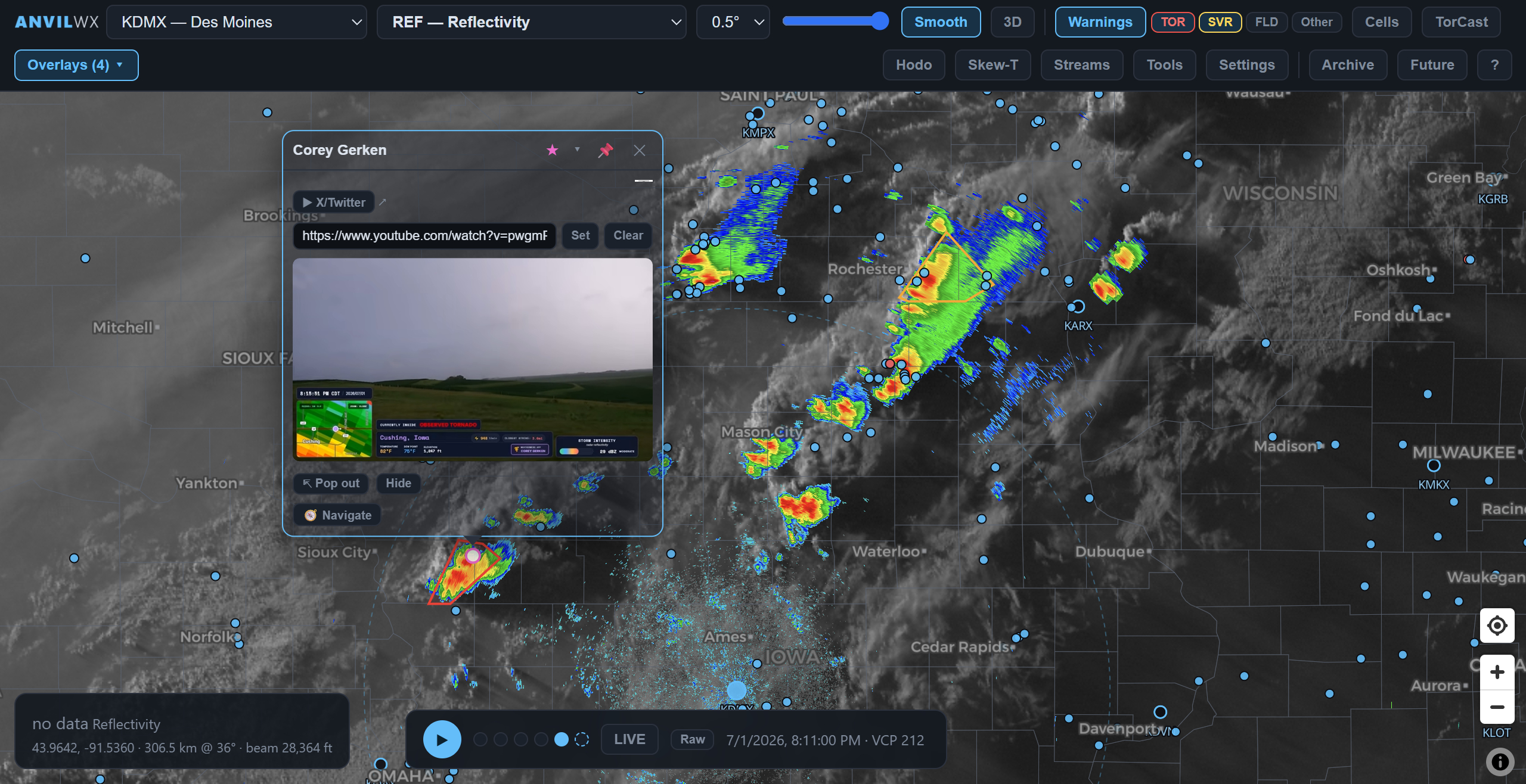
MRMS rotation tracks and MESH, SPC outlooks, watches and mesoscale discussions, CAPE/shear mesoanalysis, HRRR smoke and fire perimeters, live and archive-synced GOES satellite, GLM lightning, fronts, METARs and tropical.
Make it yours PRO
Load custom GRLevelX placefiles by URL, import GR .pal color tables or build your own in the live palette editor, pick basemaps, and sync it all across devices with your account.
Slice it, split it PRO
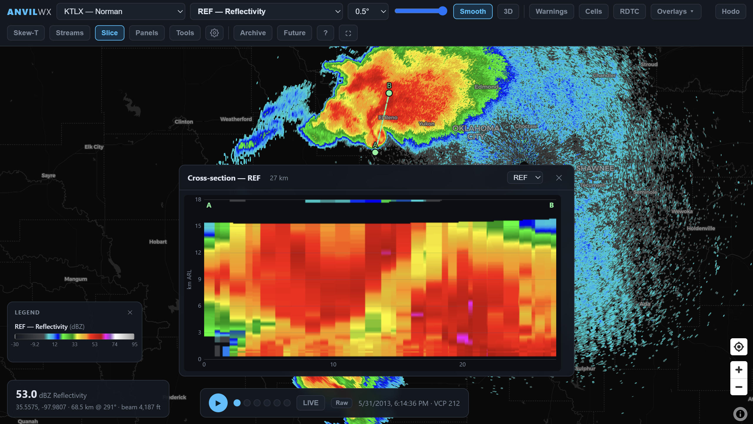
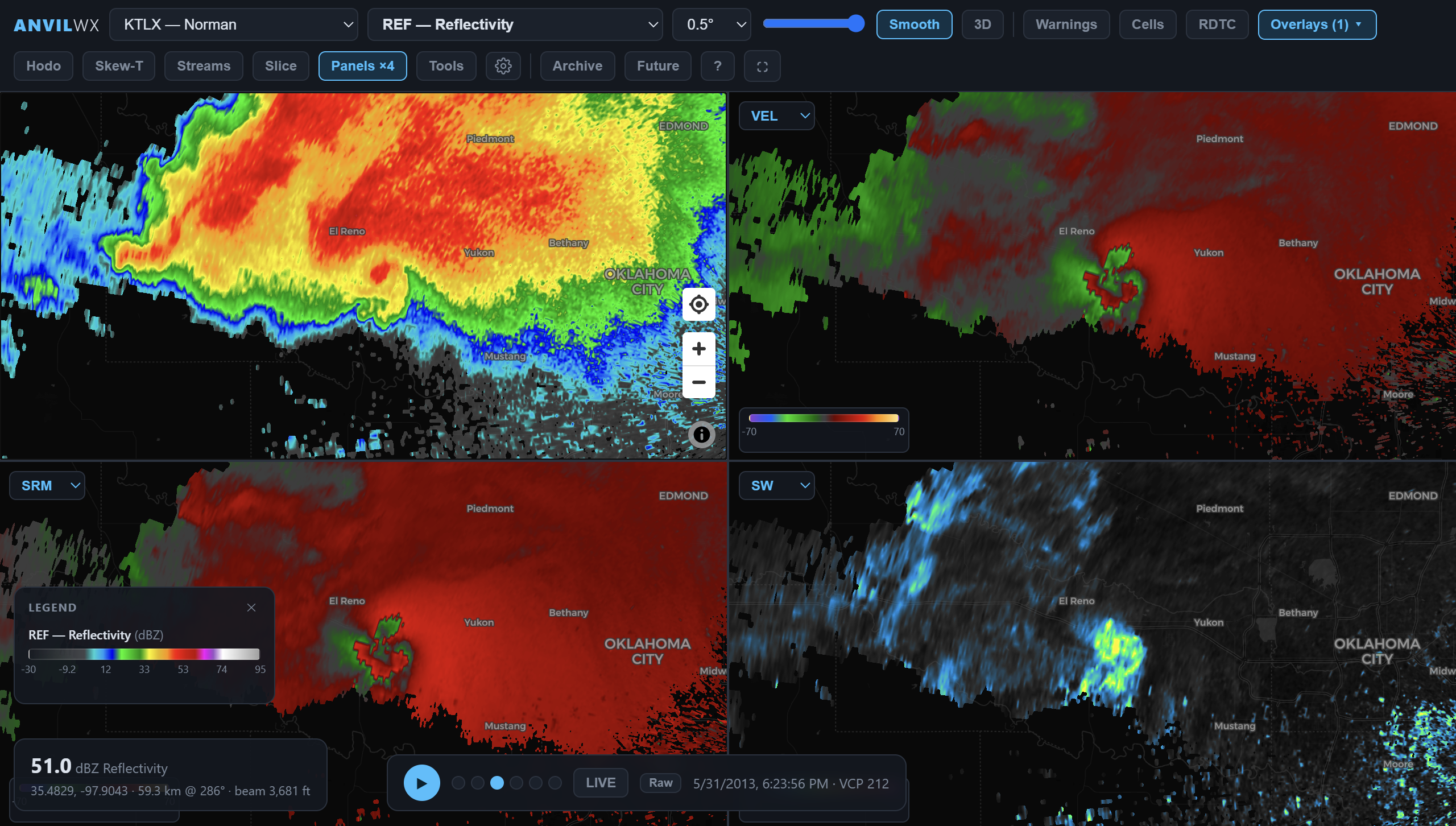
Draw a line for a live vertical cross-section through the volume, or run two-to-four synced panels — reflectivity, velocity, SRM and CC moving as one.
Tornado detection PRO
In-house rotation + debris detection with preliminary EF estimates, official TVS/meso/hail icons, a sortable storm-cell table with trends, and forecast tracks.
Chasers & broadcast tools PRO
Live chaser positions and streams on the map, picture-in-picture players — plus a full broadcaster mode with warning ticker, telestrator and a chromeless output window for OBS.
Anvil Weather is a situational-awareness and analysis tool. Storm chasing is dangerous — always follow official NWS warnings and local guidance.
In action
A workstation that looks as serious as the weather it tracks.
Replay the storms that made history
The archive reaches back to 1991, and the Notable Events catalog curates the big ones — Joplin, Tuscaloosa, Moore, El Reno, Mayfield — loaded with the surrounding scans. Overlay historical SPC storm reports, NWS damage surveys, damage paths and tornado tracks to see exactly what the radar showed as it happened.
image or GIF · 4:3 · suggested: assets/showcase_archive.gif
Storms in three dimensions
Raymarched volumes render the storm's true structure over the real map — updraft cores, hail shafts and tornado debris as floating iso-surfaces beneath a live satellite cloud canopy. Export the whole scene as a geo-anchored KMZ for Google Earth.
Two radars. Real 3D winds.
Pair overlapping WSR-88Ds and Anvil retrieves the actual three-dimensional wind field: trace air parcels along 3D velocity trajectories, watch inflow feed the updraft, color streamlines by rotation or vorticity — then export the wind data for research.
GIF or video · 4:3 · suggested: assets/showcase_dualdoppler.mp4
Stand under the storm
Street immersion mode puts you at ground level beneath the live radar volume: darkening skies, rain curtains, lightning flashes and thunder — a spotter's-eye view of the storm bearing down, rendered from real data.
video · 4:3 · suggested: assets/showcase_immersion.mp4
Scrub past the present
Future mode extends the timeline about 24 hours ahead with HRRR simulated reflectivity, updraft helicity, wind gusts, snow and freezing rain — and bridges the gap with a 0–60 minute optical-flow radar nowcast. One scrubber, past to future.
GIF · 4:3 · suggested: assets/showcase_future.gif
Ask the atmosphere anything
Pop a VAD hodograph or a model Skew-T for any point on the map, click into a storm with the Inspect tool to read every active overlay at once, or pull the full NWS forecast for the spot you clicked. Interrogation, not guesswork.
image · 4:3 · suggested: assets/showcase_interrogation.png
Slice the storm vertically
Click two points and Anvil cuts a live vertical cross-section through the volume — watch the hail core collapse or the debris signature climb, scan after scan, exactly like the big-iron analyst tools.
Four products. One motion.
Multi-panel mode keeps reflectivity, velocity, SRM and correlation coefficient perfectly in sync. Move one map and they all move — the fastest way to interrogate a rotating storm.
Layer the whole picture
MRMS rotation tracks and hail swaths, SPC outlooks and watches, CAPE and shear mesoanalysis, wildfire smoke, live and timeline-synced GOES satellite, GLM lightning, fronts, surface obs, tropical cones — every layer interrogatable, every layer yours to mix.
image or GIF · 4:3 · suggested: assets/showcase_overlays.gif
Never miss the warning
Draw the areas you care about, pick the hazards that matter, and Anvil watches the wire: instant desktop notifications and escalating tones the moment a new warning includes your location, your pins or your drawn zones — with lightning-proximity alerts on top.
image · 4:3 · suggested: assets/showcase_alerts.png
Simple pricing
Start free. Upgrade in the app the moment you need more.
Free
- Live 2D NEXRAD radar, all 160+ sites
- Reflectivity, velocity, storm-relative velocity & correlation coefficient (base tilt)
- Loop playback of recent scans
- NWS warning polygons (tornado, severe, flood & more)
- Warning alerts for your locations
Pro
- Everything in Free
- All products on all tilts + derived products
- Volumetric 3D, dual-radar 3D winds & street immersion
- Archive to 1991 + Notable Events with damage surveys
- HRRR future mode, nowcast & model overlays
- Hodographs, Skew-T, point inspection & forecasts
- MRMS, SPC, satellite, lightning, smoke, CAPE & 40+ overlays
- Tornado detection, cross-sections & multi-panel
- Custom placefiles, color tables & palette editor
- Chaser streams, broadcast tools & PNG/GIF/video/KMZ export
Secure checkout by Freemius. Cancel anytime. Pro unlocks instantly on every device you're signed in to.
Download Anvil Weather
Fetching the latest version…
Linux and Intel Mac builds are coming soon.
Updates are delivered automatically inside the app. All downloads on the releases page.
FAQ
Do I need an account to use the free tier?
Yes — a free account takes about ten seconds to create the first time you open the app (just an email and password). It keeps your settings and subscription in sync across devices, and if you ever upgrade, Pro unlocks everywhere you're signed in.
How do I activate Pro?
Upgrade right inside the app (Settings → Account, or any Pro feature's prompt). Checkout happens in-app, and Pro unlocks instantly on your account — no license keys to copy around. You can also manage billing anytime from the account page.
How many devices can I use?
Your subscription covers your personal devices — sign in with your account and Pro follows you. You can see and deactivate your active devices anytime from the account page to free a slot for a new machine.
Where does the data come from?
NEXRAD Level 2/3 and the 1991→ archive via the NOAA open data program on AWS, NWS API warnings and forecasts, SPC outlooks and reports, MRMS mosaics, GOES satellite and GLM lightning, HRRR model and smoke fields, NWS damage surveys, and Spotter Network positions.
Can I cancel anytime?
Yes. Cancel in two clicks from the account page; Pro stays active until the end of the period you've paid for, then your account simply drops back to the free tier.
Can I delete my account?
Yes — sign in on the account page and use the delete option. It permanently removes your account and synced settings and stops any active auto-renewal.
Storm season doesn't wait.
Get the workstation the storm deserves.
Download Anvil Weather